| WPC Met Watch |
|
|
Mesoscale Precipitation Discussion: #0968 (2021) |
|
(Issued at 145 AM EDT Wed Sep 15 2021
) |
|
| MPD Selection |
|
|
|
|
|

Mesoscale Precipitation Discussion 0968
NWS Weather Prediction Center College Park MD
145 AM EDT Wed Sep 15 2021

Areas affected...Much of Southern LA...Southern MS...

Concerning...Heavy rainfall...Flash flooding likely

Valid 150600Z - 151200Z

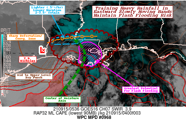
SUMMARY...Training cells within eastern bands, slowly progress
east over wetter ground continuing to pose likely flash flooding
through early morning.

DISCUSSION...GOES-E 3.9um SWIR depicts broad exposed low level
warm cloud swirl in far SE TX, while a broad shield of showers
w/embedded convective elements stretches across Central LA into SW
MS from Vernon Parish eastward, taking on more traditionally
extra-tropical patterns.  This shield is associated with a very
sharp deformation zone or effective occluded front continues to be
a focus for strong low to mid-level moisture convergence,
ascending and producing moderate shield precipitation of
.25-.5"/hr with occasional localized rates to .75" given random
deeper convective nature, mainly due to zero or very limited (less
than 100 J/kg) of instability.  Given the moisture flux
convergence along nearly orthogonal intersection of 15-20kts with
very little veering of flow; this is likely to persist through the
early morning hours given the nature of broad southerly return
flow off the Gulf into the boundary, so a narrow axis of 2-3.5"
totals remains possible over 6hrs.  This may not generate rapid
rise/flash flooding, but is probable to result in longer duration
flooding conditions.

The greater concern for excessive rainfall rates inducing flash
flooding is likely to be limited to the southeastern portion of
LA.  GOES-WV and CIRA LPW belies the main concern here, as mid to
upper level dry punch continues to rotate around the southern side
of T.D. Nicholas, with the 5-3H already as far as 90W, while 7-5H
and lesser so 850-7H remains further west near 92-93W.  The
effective 'cold' front or main eastern band lies in the deeper low
level moisture axis and remains at over 2.0" Total PWats.
Stronger deep layer convergence along the left side of the nose of
the dry air is generally aligned with coastal LA, suggesting
stronger storms in the deeper SW-NE oriented steering flow along
this moisture axis/outer band will allow for increasing rainfall
efficiency as the advance northward with 2-2.5"/hr rates likely to
be common in the strongest/deepest cores.  Cell motions will be
favorable for training as well, as eastward propagation of the
band is likely to be slow (5-10kts) allowing for increased
residency and potential for 3-5" totals by 12z.  This is more
likely to occur immediate to the coastal region where instability
(2000-2500 J/kg) from the warm Gulf/higher Theta-E air will be
regenerated and modest mid-level drying steepens lapse rates.
Updraft strength, as noted above, will diminishing quickly as
instability falls to near zero north of I-12.

To exacerbate flooding concerns further, the warm Gulf is already
modifying the lower profile west of the main axis, expanding the
effective warm sector to the circulation.  As such, additional
upstream bands are likely to form and likely to track eastward
slowly as the initial band did, tracking across areas already
affected with the earlier band.  The depth of dry air is likely to
limit the breadth of updrafts/further upstream bands nearing the
SW LA coast and so the potential reduces further south and west.

Lastly, a weak effective warm front/confluence band exists east of
the Chandeleur Islands south of Mobile Bay.  Similar deep well of
unstable, moisture rich air is available for efficient rainfall
production.  However, there is some uncertainty that the low level
moisture flux convergence will be sufficient to develop stronger
cells.  There are equal Hi-Res CAMs that support convection that
does develop will have solid potential for training across far NE
LA and the MS Coastal region with more scattered localized
flooding threat initially (through 12z).

Gallina

ATTN...WFO...JAN...LCH...LIX...MOB...

ATTN...RFC...LMRFC...WGRFC...NWC...

LAT...LON   31649095 31508952 30978860 30458845 30248859
            29998909 29528957 29099002 28959053 29089107
            29369155 29479231 29819283 30219316 30589330
            30899340 31209288 31299200
Last Updated: 145 AM EDT Wed Sep 15 2021
|


