Short Range Forecast Discussion
NWS Weather Prediction Center College Park MD
340 AM EDT Sat May 04 2024
Valid 12Z Sat May 04 2024 - 12Z Mon May 06 2024
...There is a Slight Risk of excessive rainfall over parts of the Southern
Plains on Saturday and Southern Plains, Middle/Lower Mississippi Valley on
Sunday...
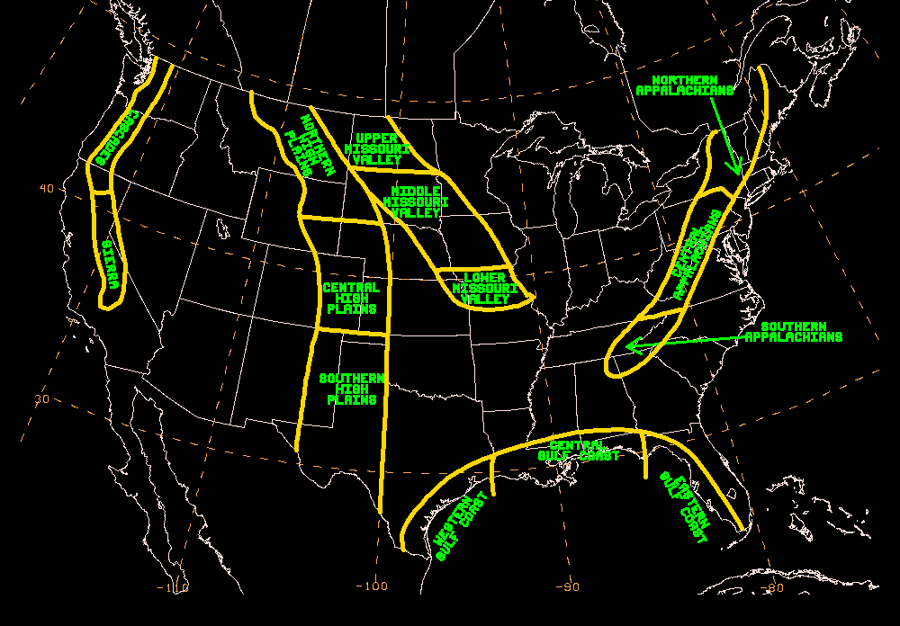
...Heavy snow over the Sierra Nevada Mountains on Saturday...
...There is an Enhanced Risk of severe thunderstorms over parts of the
Southern High Plains...
A front extending from the Great Lakes to the Southern High Plains will
slowly march eastward to the Northeast to the Ohio Valley and then to the
Southern Plains by Monday. Moisture from the Western Gulf of Mexico will
pool along the boundary over central Texas, producing showers and
thunderstorms with heavy rain. Therefore, the WPC has issued a Slight Risk
(level 2/4) of excessive rainfall over parts of the Southern Plains
through Sunday morning. The associated heavy rain will create mainly
localized areas of flash flooding, with urban areas, roads, small streams,
and low-lying areas the most vulnerable.
In addition, some of the showers and thunderstorms will be severe, posing
a significant threat. Therefore, the SPC has issued an Enhanced Risk
(level 3/5) of severe thunderstorms over parts of the Southern High Plains
through Sunday morning. The hazards associated with these thunderstorms
are frequent lightning, severe thunderstorm wind gusts, hail, and a few
tornadoes. Further, there will be an increased risk of EF2 to EF5
tornadoes and hail two inches or greater over the area. Moreover, showers
and thunderstorms will also develop over parts of the Ohio/Tennessee
Valleys and the southern mid-Atlantic/Southeast on Saturday.
By Sunday, the threat of severe thunderstorms decreases to a Marginal Risk
(level 1/5) over parts of the Southern Plains, the Lower Mississippi
Valley, and the Tennessee Valley. A second area of Marginal Risk of severe
thunderstorms will be over parts of the Ohio Valley and Lower Great Lakes.
However, the threat of excessive rainfall continues while moving eastward
on Sunday, maintaining the sense of ongoing threat. Therefore, the WPC has
issued a Slight Risk (level 2/4) of excessive rainfall over parts of the
Southern Plains and Middle/Lower Mississippi Valley from Sunday into
Monday morning. The associated heavy rain will create mainly localized
areas of flash flooding, with urban areas, roads, small streams, and
low-lying areas the most vulnerable. Additionally, showers and
thunderstorms will develop over parts of the Northeast to the Southeast.
Meanwhile, a front over the Pacific Northwest/Northern California will
move eastward Saturday to the Northern/Central High Plains and the
Southern Rockies by Monday. The system will produce rain over parts of the
Pacific Northwest and Northern California on Saturday morning. As the
front moves farther inland, the snow levels will decrease over parts of
the Northwest and California. Heavy snow will develop over parts of the
Sierra Nevada Mountains overnight Saturday into Sunday and lighter snow
over the Cascades. Rain and higher-elevation snow will continue over parts
of the Pacific Northwest. The heavy snow over the Sierra Nevada Mountains
will mainly end on Sunday. Furthermore, snow will move over parts of the
Great Basin and the Central Rockies on Sunday. Rain will move over parts
of the Northern Plains by Monday.
Ziegenfelder
Graphics available at
https://www.wpc.ncep.noaa.gov/basicwx/basicwx_ndfd.php


