| WPC Met Watch |
|
|
Mesoscale Precipitation Discussion: #0177 |
|
(Issued at 1217 PM EDT Fri Apr 26 2024
) |
|
| MPD Selection |
|
|
|
|
|

Mesoscale Precipitation Discussion 0177
NWS Weather Prediction Center College Park MD
1217 PM EDT Fri Apr 26 2024

Areas affected...central to northeastern TX

Concerning...Heavy rainfall...Flash flooding likely

Valid 261616Z - 262200Z

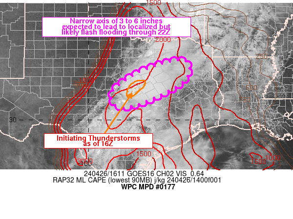
SUMMARY...A narrow stripe of heavy rain is expected to develop
from eastern portions of the Hill Country into and across
east-central TX to about I-20. 3-6 inches of rain through 22Z is
expected to lead to localized but likely flash flooding.

DISCUSSION...16Z radar imagery showed developing thunderstorms
west of I-35, including a supercell over Lampasas and Coryell
counties. This region of storms was forming just east of an upper
level shortwave seen on water vapor imagery, along the edge of
eroding CIN within a moist/unstable environment containing
2000-3000 J/kg MLCAPE as seen on the 15Z SPC mesoanalysis. 850-300
mb layer winds and Bunkers Right moving supercell motions forecast
cells to advance toward the northeast, and some expansion of
thunderstorms is expected to continue over the next 1-3 hours.

Concerns for training arise given the potential for thunderstorm
induced outflow aligning parallel to the mean steering flow, with
continued overrunning of moist/unstable air from the south over
the next few hours, with 30-40 kt of 850 mb flow from the SSW. As
cells advance northeastward, additional development will be
possible to the immediate southwest supporting a SW to NE axis of
heavy rainfall. Rainfall rates as high as 2-3 in/hr will be
possible and training is expected to support 3-6 inches across a
narrow region of central to northeastern TX. There is decent
support from recent runs of the HRRR and all components of the 12Z
HREF, excluding the 12Z FV3, for at least 3 to 5 inches of rain
through 22Z, across I-35 and I-45, south of Dallas/Fort Worth.
Confidence in this forecast scenario has increased enough to
warrant a "likely" area of flash flooding for this region of TX.

Otto

ATTN...WFO...EWX...FWD...SHV...SJT...

ATTN...RFC...WGRFC...NWC...

LAT...LON   32849540 32109526 31389620 30739778 30679862
            31459878 32499709
Download in GIS format: Shapefile
| KML
Last Updated: 1217 PM EDT Fri Apr 26 2024
|


